TGO Challenge 2013: Strathcarron to Montrose
Thursday 9th May: Arrival at Strathcarron.
Anticipation built up on the way to Strathcarron with the increasing numbers
of Challengers – a few at Queen St Station in Glasgow, hesitantly greeting each
other – “TGO Challenge?” – more flocking on to the train at Perth and Inverness –
noise levels increasing with every greeting.
There were many anxious looks out at the weather, which seemed
to be deteriorating as we travelled west.Strathcarron Hotel was friendly, welcoming and comfortable – my last night in a bed till Kincraig, last time I’d sit at a table too. Everyone was friendly, welcoming first-timers, discussing the pros and cons of routes, comparing gear.
 |
| Strathcarron Hotel |
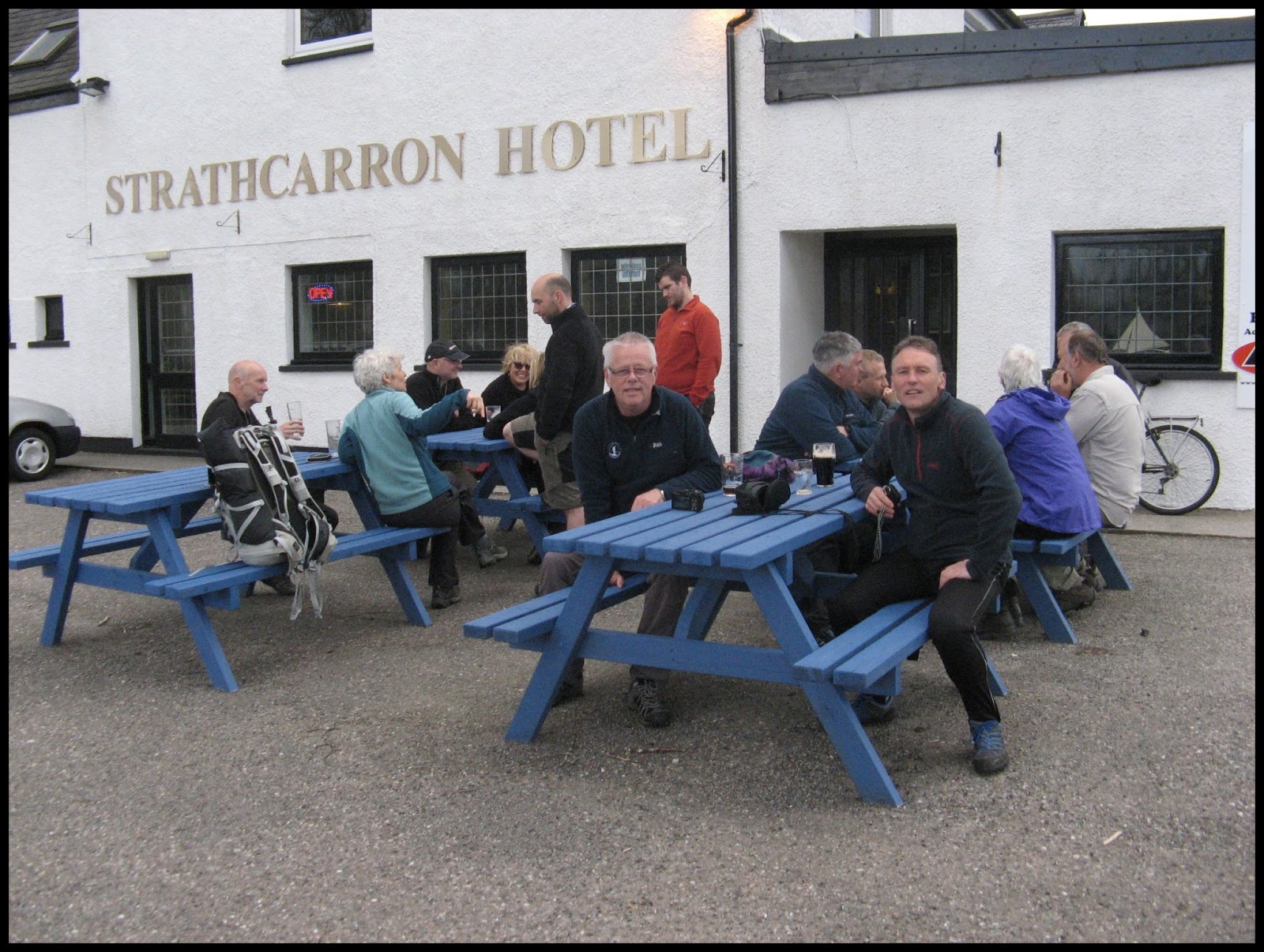 |
| Drinks outside - it was still dry on Thursday evening! |
 |
| The west coast - though well inland at the head of Loch Carron |
Friday 10th May: Strathcarron to Gead Loch
The weather was fine at first, dry with
some sunshine.
 |
| Loch Carron from above Achintee |
The first part of the route was familiar –
I had done it in reverse on a big stravaig 5 years previously.
The views back to Strathcarron and
Loch Carron constantly changed. Looking back, I also saw a line of overtaking Challengers. I didn’t worry - I am much slower than most on the Challenge, but experience has taught me what I can
and can’t do, how much I can do in a day - my days are just longer and more leisurely than most.

There was pleasant walking over remembered
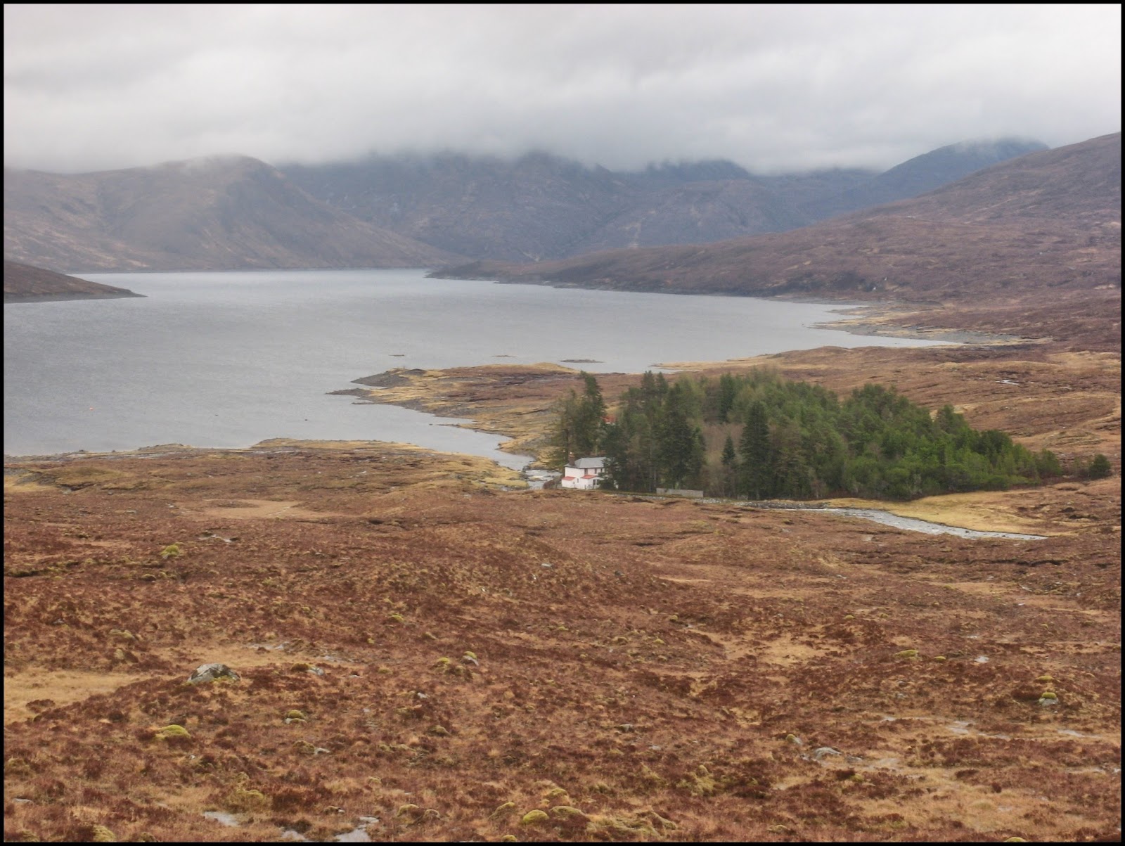
high moorland with its lochans. Over the Bealach Altain Ruaridh I had my first
sight of Bendronaig in its quiet strath. The route from the bealach down to the Bendronaig track was as rough as I remembered it. There was a lot more water in the Ling than there had been in the heatwave (remember those?) of 2008.
 |
| Lochan Fuara |
 |
| Sheasgaich and Ben Dronaig |
 |
| Ling from bridge |
 |
| Challengers nearing bothy - clouds thickening |
Rain was coming on as I reached the bothy. Lots of Challengers were inside having lunch and hoping the rain would go off. It
didn’t. Waterproofs on for the rest of the day – and for much of the rest of the Challenge. The wobbly
bridge after Bendronaig was interesting – no evidence of how the slats were attached
– I had stepped across a trickle of a burn last time.
Loch Calavie was grey under a leaden
sky.
 |
| Loch Calavie - weather getting gey dreich |
It was still at first then the wind rose,
rustling the tent.
Saturday 11th May: Gead Loch to Strath Farrar
I had read of the pathless slog to Pait
and it was a slog, as was the stretch from Pait over the bealach to Strath
Farrar. Knee-deep heather that grabbed the ankles, and peat hags, wet and
slippery, dotted with pine roots. Every time you thought you’ve picked a good
line you hit another black oozing trench. Weather dreich, rain on and off.
 |
| Approaching Pait |
Negotiating the high gate from Pait on to
the hill was probably the most dangerous bit of the whole trip. The hinges no longer attached the gate to the gatepost, so I decided to climb over at the other end, where a chain attached gate to post. The gate wobbled violently when I was half-way over, so I grabbed the top of the gatepost - mistake! the base had disintegrated and the post was even more unsteady than the gate.
I had planned to go up the west bank of
the Allt Riabachain and cross high up but spotted a bridge lower down and used it.
Jay was pitched just upstream from it. We both decided that contouring round the north side of Meallan Buidhe and up to the bealach between it and the hill to the east, was the best option.
The bealach was the usual boggy morass,
but at last I was down in Strath Farrar, first on a path, then a track which
eventually became tarmac. Burns were full, with dramatic waterfalls. There was snow high up on the
big hills at the head of the glen – it was still winter up here.
As I crossed the
Monar dams, icy wind was turning wave tops white. I met Jay again at a sheltered spot below the dam.
In the deep gorge of the Garbh Uisge below the second dam,
there were many birds in its comparative shelter, including gulls. |
| Approaching the bealach |
 |
| High up in Strath Farrar - still snow on hills above |
 |
| Further down the glen, vegetation greener, and a moment's sunlight |
As I went further down the glen it
became flatter and greener – more like the spring which hadn’t yet reached the
high glen. Weather was improving. Cuckoos called, woodpeckers drummed, a pair of
wheatears chased each other in the grounds of Braulen Lodge.
 |
| Near Braulen Lodge |
Approaching the area where I
hoped to camp, I thought it didn’t look promising – the knoll between track and river was
rough, steep and heathery. However, a few yards further on, a lovely level grassy
meadow was revealed on the east side, beside the Allt Uchd Rodha. Perfect. A
short while later Emma and Stan arrived. A dry, pleasant evening, in contrast to
the previous one.
 |
| Inchvuilt Wood from camp |
Sunday 12th May: Strath Farrar to Strath Glass
 |
| River Farrar at camp |
A showery day, as I wandered down
the lower part of Strath Farrar, spring advancing as I descended, everything
gradually becoming greener, beech and birch leaves translucent in the sunlight.
 |
| River Farrar looking downstream |
The number of trees increased, some of them so ancient that it was a wonder they still stood.
 |
| More and more trees as I went further down the glen |
 |
| Some of them incredibly old |
There was much evidence of former occupation of the glen. Many ruined houses, that once must have housed a lively community - not such a lonely life as one might think, though in those days the glen must have been more isolated than it is now - several vehicles passed as I walked. But perhaps not a life for a family - read "Isolation Shepherd"
 |
| A memorial to a resident of the glen |
 |
| One of several ruins in this part of the glen. |
 |
| This tree dominated the view down the glen for some distance |
I met a couple who asked if I was on the Challenge – he had done the very first one. Jane caught up with me and we walked the rest of the day together. The glen was noticeably quieter than Glen Affric, a result of the restriction on vehicle numbers. Sadly that hadn’t stopped people dumping rubbish in a cattle grid.

Strath Glass was flat and fertile. The last stretch of the day was a bit of a slog, up a pleasant but steep old forest track to where I hoped to find a pitch for the night – it turned out there was nowhere around the bridge but I found a good spot a little further on – a grassy patch beside the path, trees around, with a view out over them to the hills on other side of Strath Glass.
 |
| Spring in the lower glen |
 |
| A last look at the snow high up in the glen |
 |
| Sunlight on one of the lochs |
I met a couple who asked if I was on the Challenge – he had done the very first one. Jane caught up with me and we walked the rest of the day together. The glen was noticeably quieter than Glen Affric, a result of the restriction on vehicle numbers. Sadly that hadn’t stopped people dumping rubbish in a cattle grid.

 |
| The bottom of Strath Farrar where it joins Strath Glass |
 |

The morning weather alternated sunshine and showers as usual. On this trip I was taking the advice of a 2011 Challenger who assured me that bundling a sopping wet Laserlite into a poly bag and attaching it to the outside of the rucksack was the way to go in wet weather - no need to keep the dry inner and wet outer separate - it worked! As promised, the inner dried in minutes after I put the tent up in the evening.

A lovely grassy track at the start soon gave way to felled forest – I checked the GPS every so often to make sure I wasn’t on the wrong track, after finding a sizeable lochan not on the 1:50,000 map, which was a bit unnerving.

I met the Beauly to South-East England power line construction site just before the Glen Urquhart road – lots of “Keep Out” notices despite assurances from the administrative staff about rights of way.


The walk through Buntait, avoiding the main road, is lovely – spring had really arrived here. It's a popular area, with several new houses.
 |
| Buntait road |
 |
| River Glass |
 |
| Shewglie |

A pleasant walk led along grassy tracks through fields, then there was a half-hidden entrance to a very old and little-used track through woods – a great alternative to the forest track which it eventually joined, which went all the way to just above Drumnadrochit.
 |
| Entrance to the old track not very clear |
 |
| Pleasanter walking than a hard forestry road |
 |
| Challengers vanishing into the distance |
 |
| Felling operations give a clear view of Glen Urquhart |
 |
| Loch Ness appears in the distance |
 |
| A pleasant path in woodland above Drumnadrochit |
Tuesday 14th May: Drumnadrochit to Allt an Doire Leathain
 |
| Drumnadrochit |

The local ducks obviously knew that breakfast would be served on board.
We had an unusual view of the castle from the water.


We quickly arrived at Inverfarigaig Pier and leapt/scrambled/floundered ashore, before setting off at a quick march/purposeful walk/ leisurely meander.

The glen was lovely, with sunlight shining through the leaves of the birch trees and flowers bordering the road.

 |
| Primroses |
 |
| Wood anemones |
The water in the burn tumbling down the gorge alongside was deep peaty brown, with brilliant amber where the light shone through it.

Near the top of the glen I spotted a residential development opportunity - however I think a lot of drainage work would be required.

After going round the north-east end of Loch Mhor I cut up the track from Farraline towards Dunmaglass Lodge.
 |
| Looking back towards Farraline and Loch Mhor |
 |
| Challengers on the track above Farraline |

I decided on my FWA, as the alternative involved a walk along the watershed above the A9, a route which really demands a fine day with good visibility for the views. So I followed the Allt an Doire Leathain up into the hills.

I had tentatively picked a camp a couple of kilometres up the track, but it didn't look inviting, and it was still early, so I kept on going to the hut at the top of the track. By now I was encountering snow patches.

The hut was open, and some people were using it as a meal-stop. I planned first to do likewise, then thought "Why put up the tent?" and slept in the hut. It was convenient, but colder than the tent would have been. It snowed later in the evening but it had melted by morning.
Wednesday 15th May: Allt an Doire Leathain to Findhorn-Dulnain hills
Next morning I discovered a problem. I had sloshed through a couple of shallow fords the previous day, as I have done hundreds of times before. This trip, however, I had put sorbothane insoles in my boots, anticipating more road-walking than usual. During the night, they had absorbed the water from my wet boots and swelled up, leaving my feet with considerably less room even after attempts to wring them out. Today was going to be uncomfortable.

The terrain at the start of the day was uninviting - trackless peat hags. I wondered how the others had got on last night, continuing after the hut. I couldn't see anywhere much to pitch tents. I was glad to reach the tracks that would take me eventually down to the Findhorn.

 |
| Approaching the Findhorn down the Allt Calder |
 |
| First glimpse of the strath of the Findhorn |

 |
| Remains of enclosures |
 |
| Looking down the strath. |
 |
| Coignafeunternich ruins |

It was raining pretty steadily by now and I just got the head down and plodded on, trying to ignore the discomfort of my feet. I crossed the bridge to Coignafeuinternich, passed the ruins, and set off up the track over Carn Easgain Mor.
To my surprise, coming down Carn Easgainn Mor to rejoin the Allt Fionndairnich, I found an estate hut, unfortunately locked this time, but providing welcome shelter from the wind for my tent. I was tired, probably as a result of nursing sore feet over rough ground, and ready to stop, though I hadn't covered as much distance as I'd planned.
I used the verandah of the hut to cook in relative shelter and comfort. I had been starting to worry about the gas canister - a different make from usual, and it didn't seem to be giving as much power as I'd expected - I normally don't have to turn my Primus Alpine stove up very high to heat water quickly, and now it was turned up full and taking ages. Using a selection of Outdoor Grub's "eat out of the pouch" meals, and soaking oatmeal overnight for porridge, I hadn't had the stove on for very long each day. I decided to keep my phone on next day and as soon as I got a signal I'd text the friend who was meeting me at Kincraig and ask her to bring a replacement canister.
Next morning was dry, the wind had dropped and the tend was stiff with frost.
I decided to try walking with two pairs of socks and no insoles, to see if that was more comfortable.
Thursday 16th May: Dulnain to Kincraig
The track past the bothy unfortunately went south-west, and I was headed south-east to Kincraig, so after a short distance, which involved a patch of hard snow, it was more peat-hags and knee-deep heather.

 |
| Looking back at the bothy from where I left the track |
 |
| Grass beside the burn made for easier walking |
 |
| Back to the peat hags, this morning decorated with a powdering of snow |
 |
| The Dulnain comes into view |

 |
| The Dulnain, looking upstream |
 |
| The Dulnain, looking downstream |

Following the river down was fairly easy walking. I crossed it quite high up, to a faint track.
 |
| At times a bit of boulder-hopping was needed |

I passed a hut on the other side, then the track turned up over the north-east ridge of Carn Dulnan, passing some communication masts - so that's why I'd got a signal high on the slopes above the upper Dulnain.
 |
| Looking back at the Dulnain - hut just visible |
 |
| Why I got a phone signal? |
 |
| Cairngorms come into view |

Where the track crosses the Feithlinn, which then joins the Dulnain, I found a bothy which made a good lunch spot before the final pull up to Carn Coire Dhugain and the long descent to the A9.
 |
| "For goodness sake, hurry up and take my photo" |
 |
| "Have you come to feed us?" |
 |
| Even the geese at Leault Farm are fairly tame |
 |
| Fresh fruit! Lettuce! |
Friday 17th May: Kincraig to Eidart
Irene and I set off from Milehouse through Inschriach Forest on a pleasant sunny morning. For me, Glen Feshie has always been somewhere on the way to high hills, and it was nice to enjoy the glen for its own sake, at a leisurely pace.
 |
| Inschriach Forest |
 |
| Wood anemones |
 |
| Wood sorrel |

 |
| Looking upstream from the bridge near Stronetoper |
 |
| Looking downstream from the bridge |
 |
| Looking up into Coire Garbhlach |
The amount of work that has been done on the paths is very noticeable all the way up the glen.


 |
| This tree seems to have started by leaning one way then changed its mind. |
 |
| I might have expected to see more water in the Feshie |
 |
| Primroses |

 |
| Waterfall opposite Creag Bheag |

Saturday 18th May: Feshie to Fealar Lodge
The weather had changed by morning - grey and dreich. We had camped just before the River Eidart, which looked dramatic as it roared under the bridge.


After leaving the Feshie and crossing the watershed, we went down to have a look at the Geldie, which had a lot of water in it even high up. We decided to cross over rather than following the path down to Fords of Bynack and risking not being able to get across there. To begin with, the walking was fairly easy, on the flat grass bordering the river, but it became progressively rougher, with knee-deep heather catching the legs at every step. The weather, too, was deteriorating further - wet, cold and windy - altogether pretty miserable. I was glad to have Irene's cheery company for this bit of the trip.
 |
| Near the top of the Geldie |
We stopped at the ruined Bynack Lodge for hot soup, which cheered us up a bit. We had thought of camping somewhere up the Allt an t-Seilich but everywhere was wet, windswept and uninviting. Suddenly we were on the bealach, a featureless boggy expanse. We headed off on a compass bearing over Sidhean Bealaidh, from which we glimpsed Loch Tilt briefly through the mist and rain (no photos from this bit - cameras tucked away in waterproof bags). A post briefly glimpsed on the skyline gave us something to aim for between Meall na Cailleach Buidhe and Meall Chrombalg, from where we followed traces of tracks down towards Fealar Lodge. We were quite sure we'd navigated accurately in the mist, and the lie of the land matched the map, but where was the forest that should have been on the south-west of Meall Chrombal? We should have been following the edge of it. We came to the conclusion that the land was zoned for forestry but not yet planted.
 |
| Nearing Fealar Lodge - not a tree in sight, despite what the map shows. |
A short way after Fealar, we found a little flat patch of grass in a sheltered gully - this would do. Miraculously, the rain stopped, and we got the tent up. I sat down in the tent for a minute and fell asleep.
Sunday 19th May: Fealar to Spittal of Glenshee
Next morning we woke in mist, but no rain.


We packed up and set off over the south-west shoulder of Carn Dearg, down across the Allt a' Ghlinne Bhig, and up to the bealach between Carn an Righ and Mam nan Carn. I remembered camping in this area many years ago, in late May, and waking to find the world outside white with snow. This time everything was white with mist as we plodded up the corrie, with only one snow patch, and the mist was drifting and breaking up slowly.


Near the bealach we noticed a couple of posts with rings, and a cairn-like shelter nearby - we reckon this would probably be where stalkers with ponies would wait till they were sent for to collect a stag carcass.

At last we reached Loch nan Eun, the loch of the birds. There were no birds in evidence when we were there - all was perfectly still - the silence you only find so rarely even high in the Scottish hills - no faint rushing of a distant burn, or even the whisper of the wind on the grass. Glimpses of the surrounding hills came and went as the mist moved.


At the loch's outlet, the burn tumbled down into a series of waterfalls, beside which the path zigzagged down steeply.Beyond, we could see the long stretch of Glen Taitneach winding down to the Spittal.


Near the foot of the glen Irene began to look out for her father, who was coming to meet us. Behind us, the hills through which we had walked in the morning mist were tiny in the distance.


At the hotel, we met people who had run there from Blairgowrie - an inconceivable feat by my standards. We also met several Challengers, and I decided to treat myself to a night's B&B. Irene and her father set off for home, saying, "It'll all be easy now - just across the foot of the Angus glens and you're done."
Monday 20th May: Spittal of Glenshee to Kilbo, Glen Prosen
The first part of the day's route led along the Cateran Trail, then up to Loch Beanie. I encountered several Challengers, all moving briskly compared to me. It was a fine morning, inviting lots of photo-stops.
Loch Beanie was a quiet, peaceful spot - it would be pleasant to camp there some time. It even has a beach!
 |
| Looking back at Spittal of Glenshee from the Cateran Trail |

 |
| Looking back at Spittal from the path to Loch Beanie |
 |
| Loch Beanie |
 |
| Loch Beanie |
 |
| Loch Beanie |
 |
| Looking over to Glen Isla |
 |
| Coming down into Glen Isla |
 |
| New bridge in Glen Isla |
 |
| Burn above Dalhally |
 |
| Looking back across Glen Isla from above Dalhally |
The stretch up Mid Hill towards Bawhelps was a bit of a slog - a fairly featureless stony track - better than knee-deep heather and peat hags, I suppose. The snow patch on the skyline never seemed to get any nearer. The weather was deteriorating too - an icy cold wind and intermittent sleety rain. I decided to give the summit of Bawhelps a miss - it looked like just another featureless heathery lump.
 |
| Skyline between Mid Hill and Craig Lair |
 |
| The extraordinarily- named Bawhelps - a very ordinary hill |
I planned to get down into Glen Prosen via the Glack of Balquhader, which looked quite steep on the map, and on approach, but it turned out straightforward - a quick way down to where a smooth patch of grass beside the burn invited a tent. The weather improved again and I sat outside eating dinner and wondering here the Challengers I'd seen in the morning were camped now. I thought I'd seen someone on the Kilbo track as I pitched the tent.
 |
| The Glack of Balquhader, easier than the map suggested |
 |
| Camp below the Glack, looking towards Kilbo |
Tuesday 21st May: Kilbo to Glen Moy.
I was up and away early next morning. Snoring was emanating from an Akto pitched near the track just before Kilbo.

Where there had been only a ruin before, at Kilbo, there was now a sizeable building going up, and as I walked on down the track I met several vehicles coming up.
Something I noticed all over the Angus glens was the presence of traps on poles placed over ditches - none seemed to have caught anything - I wondered if they were to trap rats.

 |
| The White Glen |

Further down the glen, Glen Prosen Lodge was undergoing extensive renovation and extension, again with a lot of people working there.


As I went further down the glen, everything got greener and more fertile-looking. Ground was being drained and ploughed. Looking across to Balnaboth, I could see what looked like a big variety of trees planted, and somewhere I could hear what sounded like a peacock screeching, adding an exotic touch to the sound of cuckoos, peewits and whaups, and various unidentified little brown twittering things in the hedges.
After a long stretch on a hard surface, it was a relief to turn off up a grassy track, which led up on to the shoulder of Cairn Leith - grouse moor country again, with many grouse butts.

 |
| Cairn Leith |
 |
| Grouse butt |
 |
| Glen Cally |
 |
| Glen Clova from Sneck of Corinch |
 |
| What you don't want to find upstream from your camp |
 |
| Looking across to track leading up from Gella |
 |
| Glen Clova |
 |
| Glencuilt in distance, several zigzags away |
 |
| Approaching Glencuilt |
 |
| Camp beside the Burn of Glenmoye |
Wednesday 22nd May: Glen Moy to Caterthuns
I had planned to go over Auld Darkeney, just because of the name, but it didn't look all that enticing, and I wasn't sure if I might encounter some of the famous Angus double electric fences, so stuck to where I had a continuous track, via Hillsise, Buckies and Baikies to Genogil.
Hillside looked inhabited, but all was quiet as I passed in the early morning. I looked back at yesterday's route, over the Sneck of Corinch, now on the skyline.
 |
| Looking back towards Sneck of Corinch |
 |
| Buckies from track |
 |
| Buckies from another ruin |
 |
| Approaching Buckies steading |
 |
| Buckies chimney |
Further on, Baikies was still in use.

The track followed woodland to Glenogil.


The sun was out, birds were singing, Glen Ogil was green and lovely after the bleak moorland. Flowers bloomed at the roadsides, sunlight shone through fresh young leaves.


A picturesque lochan reflected the morning light.

On the spur of the moment I decided to continue along the road rather than going up along the Menmuir Hills. As I reached the place where I would have turned off, a bitterly cold wind convinced me I was right. That was summer, that was.
To begin with it was interesting looking at the immaculately drilled fields, and all the work going on, but after a while that palled; however, when heavy rain squalls started I was glad not to be high up on the Menmuir Hills, but sheltering behind the village hall at Kirkton of Menmuir.


When I reached the road leading up to the Caterthuns, and saw a little sheltered wood beside the road, it seemed a more attractive camp spot than the top of one of the iron age forts, which was where I had originally planned to camp. The wind was rising and rain squalls were becoming ever more frequent. I pitched the tent and walked up to have a look at the forts - the sort of place that demands more time than I had on a cold evening with dinner beckoning from the tent.
Later that night I felt cosy and secure as the wind and rain blasted the tent.
Thursday 23rd May: Caterthuns to Montrose
With a long road walk in prospect, I packed up quickly and set off, promising myself a fry-up at the services at Stracathro. The weather wasn't great, and the camera was tucked away in its waterproof bag in the rucksack for most of the day. I managed to turn a shortcut into a long way round at Chapelton and Cairndrum, where there were new buildings where I expected a track. After Stracathro I ran into Jean Turner, who recommended the tearoom at House of Dun; however I found the back gate I would have used was now padlocked, so decided to revert to my original plan of using a marked track via Langley Park to avoid some main road - the track ran out in undergrowth so I cut down on to the main road a little earlier than intended and followed it to the "Montrose" sign, where I got the camera out.
After that there was the prospect of tricky navigation through Montrose - though it turned out that all Montrose residents, seeing a weary walker with a large rucksack, merely ask whether you want to be directed to the camp site or the Park. Then down to the sea, dip the boots in the water, fix a distinctive carabiner to the tent in the camp site so as to be sure of identifying it later, and dinner at the Park.

 |
| The North Sea |

 |
| Dip feet in sea |
 |
| The camp site, conveniently close to the shore |
 |
| Tent city beginning to gather |
Hi Marion
ReplyDeleteA very enjoyable read, I look forward to the next installment.
Louise Evans
From one "technological illiterate" to another, it looks good to me!
ReplyDeleteA very nice easy style and some great pictures - I love the description of the water.
Onward to the next part please!
:-)
Nice one Marion....and you clearly had no problem with the technicalities of creating and writing your blog, you've done splendidly!
ReplyDelete....and to echo Alan's comment: Next!
JJ
PS: You don't strike me as a 'Biddy'!
A well designed and thought out blog, Marion. Love the pics!
ReplyDeleteA very good read, Marion.
ReplyDeleteAnd, very good photos.
It was good to say a brief - hello - on the way to Drumnadrochit.
Nice pics.
ReplyDeleteBrought back many memories of past routes.
Looking forward to next bit now.